Everything you need to know about Sailing in Papua New Guinea

Sailing in Papua New Guinea (PNG), situated just south of the equator, offers a rarely trodden sailing frontier. Its archipelagic expanse, encompassing thousands of islands, provides diverse cruising grounds far removed from the busier yachting hubs of the South Pacific. For the adventurous sailor—eager to explore remote atolls, dense mangrove-lined passages and volcanic landscapes—PNG delivers an experience unlike any other. This guide provides an overview of the primary sailing areas, prevailing winds and climatic patterns, key harbours and anchorages, and essential information on chartering. By the end, you will have a clear sense of what to expect and how to prepare for a voyage in these waters.
Geography and Sailing Regions
Papua New Guinea at a Glance
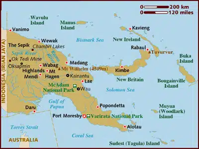
PNG comprises the eastern half of the island of New Guinea (the world’s second-largest island), as well as numerous outlying archipelagos. Its coastline stretches 5,152 km and is fringed by reefs, lagoons and deep channels. The main sailing regions can be grouped into four broad areas:
- Mainland Coast and Milne Bay
- New Britain and New Ireland
- Bougainville, Buka and the Autonomous Region
- The Louisiade Archipelago and South-East Islands
Each region has its own sailing characteristics, from sheltered passages to exposed sea lanes between volcanic chains. Below, we outline these areas in more detail.
Mainland Coast and Milne Ba
Southern Coastline and Port Moresby
- Port Moresby serves as PNG’s capital and principal port of entry. The harbour is well-protected but offers limited marina facilities.
- Coastal cruising along the southern mainland, from Daru to Alotau, features broad bays, mangrove creeks and occasional reef passages.
- Milne Bay, at the eastern tip, is a highlight: here, deep bays (e.g., Samarai, Boia) and coral islands provide excellent anchorages.
Northern Coastline (Madang to Wewak)
- Madang: Known for its excellent anchorage, Madang’s harbour entrance is well charted and offers a small marina.
- Lae: A major cargo port; few facilities for yachts, but serves as a gateway for provisioning.
- Wewak and Vanimo: These northern ports offer anchorage opportunities and entry points to Manus Island further north.
New Britain and New Ireland
New Britain
- Rabaul: A deep-water harbour formed by a collapsed caldera, surrounded by volcanic peaks. It is one of the safest anchorages in PNG, though ashfall can be an occasional concern during eruptions (e.g., from Tavurvur).
- Kimbe Bay: To the west of Rabaul, Kimbe is famed for its world-class diving. Numerous sheltered anchorages lie between volcanic islands.
New Ireland
- Kavieng: The principal yacht hub in New Ireland. Kavieng Harbour is relatively small but offers duty-free fuel and modest provisioning.
- Sailing up and down New Ireland’s east coast reveals a sequence of sheltered bays (e.g., Namatanai), with reef-fringed waters and indigenous villages.
Bougainville, Buka and the Autonomous Region
Bougainville Island
- Buka Passage: The strait between Bougainville and Buka islands is deep and well-charted, but strong tidal currents demand careful timing.
- Buka Town: Offers limited marina facilities and basic provisioning; local agents assist with customs and immigration.
Autonomous Region of Bougainville
- Being under special status, formal entry procedures may differ slightly. Bougainville’s north coast has remote anchorages, but navigational data can be scarce. Engage local knowledge before venturing.
Louisiade Archipelago and South-East Islands
- Comprising over 30 islands south-east of Milne Bay, the Louisiade Archipelago (e.g., Misima, Tagula) is extremely remote.
- Louisiade’s Highlights:
- Crystal-clear reefs and meshed passages require up-to-date charts.
- Limited land facilities; self-sufficiency in food, water and spares is essential.
- Contact village headmen well in advance to arrange courtesy calls and ensure respectful visits.
Winds and Climate
PNG lies at the confluence of monsoon patterns and trade winds, resulting in a tropical climate with significant regional variation.
Seasonal Overview
| Season | Months | Wind Direction | Rainfall Pattern |
|---|---|---|---|
| Dry Season | May – October | South-East Trades (SE) | Generally lower rainfall, especially in the south (Port Moresby < 1,000 mm annually) |
| Wet Season | November – April | North-West Monsoon (NW) | Heavy rains, thunderstorms; highland areas may exceed 8,000 mm annually |
Note: Localised terrain-driven anomalies can override broad seasonal patterns. For instance, coastal PNG might experience rain year-round due to orographic lift from nearby mountains.
Monthly Climate Details
May to October (Dry Season)
- Wind Strength: 10–20 knots from the south-east, easing in July and August.
- Visibility: Generally good, with lower humidity along the southern coast.
- Sea State: Swells from the south-east can affect Louisiade and southern New Britain passages; sheltered in protected bays.
November to April (Wet Season)
- Wind Strength: 10–15 knots from the north-west, interrupted by thunderstorms (especially December–February).
- Rainfall: Heavy tropical showers; reduced visibility; potential for localised flooding (particularly in river estuaries).
- Cyclone Risk: PNG rarely experiences direct hits from tropical cyclones, but northern areas (Manus, Bismarck Sea) can be affected between January and March.
Wind Diagrams and Tables
To aid navigation planning, refer to the table below for average monthly wind directions and speeds. (Data derived from Blue Green Atlas and local yacht reports.)
| Month | Prevailing Wind Direction | Average Wind Speed (knots) | Rainfall Tendency |
|---|---|---|---|
| January | NW | 12–15 | High (thunderstorms) |
| February | NW | 12–15 | High (cyclonic risk north) |
| March | NW | 12–14 | High |
| April | Transition (NW → SE) | 10–12 | Reducing |
| May | SE | 10–18 | Low |
| June | SE | 12–20 | Low |
| July | SE | 10–18 | Low (ideal cruising) |
| August | SE | 8–15 | Low |
| September | SE | 10–16 | Low |
| October | Transition (SE → NW) | 8–12 | Increasing |
| November | NW | 10–16 | High |
| December | NW | 12–18 | High (thunderstorms) |
Key Harbours and Anchorages
Port Moresby
- Facilities:
- Port security is tight; vessels must anchor off designated points.
- Limited marina: privately owned “Port Moresby Boat Club” (book ahead).
- Duty-free fuel, basic chandlery, and provisioning hubs within the city.
- Anchorage:
- Taurama Bay: Main anchorage for visiting yachts; 10–15 m depth, sandy bottom.
- Redscar Bay: Further west; quieter but requires careful navigation around reefs.
Rabaul (New Britain)
- Facilities:
- Government-run wharf for customs and immigration formalities.
- Limited shore services: diesel (bring jerry cans), small chandlery, village markets.
- Anchorage:
- Simpson Harbour: Deep and sheltered; watch for slight sulfur smell during volcanic activity.
- Ataliklikun Bay: East side of Matupit Island; good protection from northerly winds.
Kavieng (New Ireland)
- Facilities:
- Small marina (floating pontoon) managed by local yacht club.
- Fuel dock (diesel only), provisioning (supermarket, bakeries), basic medical clinic.
- Anchorage:
- Kavieng Harbour: Layers of coral bommies; a single marked channel leads to anchorage in 7–12 m.
- Namatanai Anchorage: South side of New Ireland; deep-water anchorage with local village support.
Madang
- Facilities:
- Madang Wharf: For customs clearance; no formal marina but clubs offer dockage.
- Limited chandlery; larger supply run requires trip to Port Moresby.
- Anchorage:
- Bismark Sea Anchorage: Between Madang town and Hatang Island; depths 8–15 m, sandy bottom.
- Northeast Bay: Sheltered from SE trades; access is restricted by coral reefs—use local guidance.
Bougainville and Buka
- Facilities:
- Buka Town: One small wharf for clearance, basic provisioning, and diesel; no marina.
- Limited medical services—carry comprehensive first-aid kit.
- Anchorage:
- Buka Passage: Anchor off town at 10–18 m; strong tidal currents require swinging room.
- Green Island: West of Buka; 5–12 m sandy anchorage; sheltered from prevailing winds.
Louisiade Archipelago
- Facilities:
- Virtually none.
- Reliance on local villagers for fresh water and minimal supplies.
- Carry spare fuel and emergency provisions.
- Anchorages:
- Misima Island: West coast anchorages seasonally wind-sheltered; coral reefs demand vigilance.
- Tagula Island: Eastern edge of Louisiade; preferred if approaching from Coral Sea.
- Panasia Atoll: Small lagoon entrance; requires calm conditions and local guidance.
Chartering in Papua New Guinea
Chartering a vessel in PNG is less common than in popular Pacific destinations. However, a handful of operators cater to visiting yachts, offering bareboat and skippered charters. This section outlines the key considerations for chartering here.
Available Charter Operators
| Operator | Location | Vessel Types | Notes |
|---|---|---|---|
| PNG Yacht Charter | Port Moresby | Monohulls, Catamarans | Limited fleet; often needs advance booking |
| Pacific Sailing Charters | Kavieng | Monohulls | Local skipper recommended; vessels vary from 30–45 ft |
| Adventure Yacht Safaris | Rabaul | Motor Catamarans | Focus on dive safaris; not bareboat |
Tip: Charter availability can change rapidly; contact operators at least three months in advance, especially if intending to cruise during July–August peak.
Certification Requirements
To charter a yacht in PNG, most operators require:
- Valid International Certificate of Competence (ICC) or an equivalent recognised sailing licence.
- VHF radio operator’s licence: Mandatory for communicating with harbour authorities and other vessels.
- Proven sailing experience: Evidence of passage-making experience (e.g., logbook entries demonstrating coastal hours and night passages).
Insurance and Safety
- Third-party liability insurance: A charterer must tender proof of valid insurance covering potential damage and injury.
- Safety equipment: Operators supply life-rafts, EPIRBs and basic first-aid kits. Verify all gear is in date.
- Local regulations: Familiarise yourself with customs regulations for canoe-entry villages; some communities require gifts (e.g., kava, cloth) as tokens of respect.
Health, Security and Practical Considerations
Health Precautions
- Vaccinations: Yellow fever certificate if arriving from an infected zone; routine immunisations (typhoid, tetanus, hepatitis A/B).
- Malaria prophylaxis: Highly recommended, especially when cruising inland estuaries or rivers.
- Medical kit: Include anti-malaria tablets, broad-spectrum antibiotics, rehydration salts and a robust first-aid manual.
Security Considerations
- Certain areas of PNG, particularly parts of the Highlands and remote western provinces (West New Guinea border regions), can be volatile.
- Stick to mainstream cruising areas—Milne Bay, New Britain, New Ireland and northern mainland—where local security arrangements are in place.
- Hiring a local guide (fixer) can mitigate misunderstandings in villages; display respect for local customs and pig regulations.
Customs and Immigration
- Ports of Entry: Port Moresby, Rabaul, Madang, Kavieng, Buka, Lae, Wewak, Vanimo, Alotau.
- Formalities:
- Anchor off the designated clearance anchorage; contact port authority on VHF Ch 16 or Ch 6.
- Immigration clearance usually takes 2–3 hours; surrender passports for processing.
- Customs often require inspection of sails, dinghies, fishing gear and medical kits.
FAQs
References
-
- CruisersWiki. “Papua New Guinea.” World Cruising and Sailing Wiki. Retrieved August 15, 2018.
-
- Wikipedia. “Papua New Guinea.” Last modified May 19, 2025.
-
- Wikipedia. “Geography of Papua New Guinea.” Last modified May 19, 2025.
-
- Noonsite. “Papua New Guinea: Do Your Homework for an Amazing Experience.” Last accessed June 2025.
-
- The Hacking Family. “Cruising PNG.” Last accessed June 2025.
-
- Blue Green Atlas. “The Climate of Papua New Guinea.” Last modified 2024.
-
- Soggy Paws. “Papua New Guinea Compendium (Rev 2025.1).” May 18, 2025.
-
- Sailing Totem. “Gentle Introduction to Papua New Guinea.” Published 2012.
